Network Connectivity--A Close Analysis of the Baltimore and Ohio Railroad's Expansion
- Baltimore and Ohio Railroad, 1860
- Baltimore and Ohio Railroad, 1870
- Baltimore and Ohio Railroad, 1880
- Baltimore and Ohio Railroad, 1890
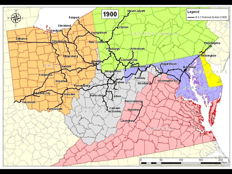
- Baltimore and Ohio Railroad, 1900
- Baltimore and Ohio Railroad System Growth
Baltimore and Ohio Railroad, 1900
Keywords
- Category: Historical GIS Images
- Topic: Expansion
The opening up of the North American continent by the railroads is arguably one of the greatest achievements of the 19th century industrial revolution. While the majority of railroad network expansion took place in the USA, important developments were also made in Canada and Mexico. By 1850, a generation after the technological feasibility of steam locomotion had been demonstrated on the Stockton and Darlington Railway in England, approximately 9,000 miles of railroad track had been laid in the USA. By the end of the century, the total mileage had soared to more than 190,000 miles, spanning the length and breadth of the country (Stover, 1999).
Significant network development commenced in New England and the Middle Atlantic States during the 1840’s, spreading into Ohio and the Mid-West in the early 1850’s, with Chicago and St. Louis as key interior destinations. Westward expansion across the Great Plains was given huge impetus by the completion of the transcontinental railroad, joining the Atlantic and Pacific coasts, when the last spike was driven at Promontory Summit, Utah in May, 1869. In terms of network density, the South lagged well behind the Northeast before the Civil War, although there was significant new construction in this region at the end of the 1850’s just before the War commenced. The North-South disparity in overall rail service provision persisted throughout the 19th century, although there was major infilling, both in the South and Southwest, from the 1870’s onwards.
Simple maps of network density by state or county conceal, however, much more complex and often rapidly changing patterns of accessibility to natural resource deposits, increasingly specialized agricultural regions and urban markets. The latter were also major sources of manufactured goods, sourced either from imports or domestic production, which needed to be transported to the burgeoning populations of immigrant settlers and farmers in the Mid-West and beyond.
One very important early attempt to visualize how the railroads compressed time and space by 1857 to facilitate access to the continental interior, is the well-known series of historical atlas maps produced by Paullin in 1932. However, on closer examination, his perspective is very much centred on New York and implies a much more homogeneous 'surface of accessibility' than was actually the case until at least the 1880's. In fact there were major accessibility variations across even those north-eastern states where railroad development was most advanced, including, for example, significant 'holes' in the surface in NW Pennsylvania and across wide swathes of southern Ohio. Likewise, the actual time-cost of overcoming distance was heavily mediated not just by line network connectivity in a geometric sense, but by freight interchange problems due to changes of track gauge, proximity to an evolving landscape of depot construction, train frequencies, presence of single or double-tracked lines (the latter dramatically reducing timetable delays) and the availability or otherwise of express passenger/freight services. To this must be added the further problem of rapidly changing commercial alliances between railroad companies and complex organisational shifts when ambitious companies assumed (and often subsequently lost) control over both larger and smaller corporate entities, in their bids to build progressively larger regional systems of lines.
Mechanisms for taking control of other railroads were many and varied. The simplest method was outright purchase, canceling all shares previously issued by the purchased railroad, and redeeming any obligations associated with its bonded indebtedness. In many cases, however, takeover was by means of lease for an extended time period, often 99 or even 999 years. A lease meant that the lessor railroad assumed the obligations of paying both the interest on the bonded debt and also guaranteeing regular dividend payments on the shares, e.g at 6%. The latter provision made a lease very attractive to shareholders of the leased railroad, since they were now guaranteed regular dividend payments, regardless of whether or not the leased railroad operated profitably. The lease was highly desirable for the lessor railroad, as it meant the lessee could thereafter be operated as part of the lessor’s system of lines. However, from a financial perspective it was potentially more problematic for the shareholders of the lessor company. This was because the provisions of the lease had to be met as a prior charge on the profits of the company, while dividends, if any, were paid from the residue. Also, the provisions of the lease had to be met regardless of business conditions, or it would be abrogated, providing an opportunity for a new lease by a competitor railroad. A further important mechanism for control was through majority stock ownership, as this would enable the controlling railroad to install a number of directors favourable to its interests on the Board of the target company. A variety of other mechanisms, such as operating agreements, freight interchange agreements and traffic sharing agreements also provided varying degrees of control. Over time, the more binding types of control described earlier often followed such initial agreements.
In consequence, account must be taken of the organizational and economic superstructure of the railroad industry, as well as the network connectivity, in understanding the changing patterns of commodity flows and passenger traffic between settlements, towns and cities and their role within the wider context of overall regional economic development. Without actual track connections on the ground it was impossible for efficient freight transfer between railroads to take place, yet at the same time, the existence of such connections did not guarantee freight interchange if the railroads involved were not operating on ‘friendly’ co-operative terms. And as a cautionary footnote, when considering small scale digital maps of large areas of the USA, the fact that specific towns were served by multiple railroads should not be taken to imply that there were necessarily track connections between these railroads, especially in the antebellum era.
References
Chandler, A.D. (1977). The visible hand: the managerial revolution in American business. Cambridge, Massachusetts: Harvard University Press.
Dilts, J.D. (1993). The Great Road: the building of the Baltimore and Ohio, the nation's first railroad, 1828-1853. Stanford: Stanford University Press.
Edson, W.D. (1993) Railroad names : a directory of common carrier railroads operating in the United States, 1826-1992. Potomac, Md. : McClain.
Healey, R.G. and Stamp, T. (2000) Historical GIS as a Foundation for the Analysis of Regional Economic Growth : Theoretical, Methodological and Practical Issues. Social Science History, 24, 3, 575-612.
MacAvoy, P.W. (1965). The economic effects of regulation: the trunk-line railroad cartels and the Interstate Commerce Commission before 1900. Cambridge, Massachusetts: MIT Press.
Schotter, H.W. (1927). The growth and development of the Pennsylvania Railroad Company. Philadelphia: Allen, Lane and Scott.
Stover, J.F. (1999). The Routledge historical atlas of the American railroads. New York: Routledge.
Taylor, G.R. and Neu, I.D. (1956). The American railroad network 1861-1890. Cambridge, Massachusetts: Harvard University Press.